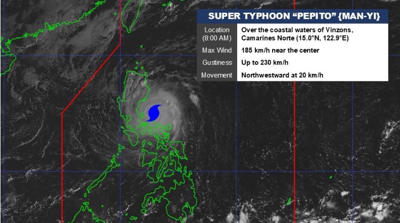
Quezon City – Super Typhoon Pepito (Man-yi) was crossing the sea east of Quezon province after traversing the waters of North Caguas Islands early Sunday morning, Nov. 17, state weather bureau PAGASA said.
In its 8 a.m. weather update, PAGASA said that the center of Pepito’s eye was estimated to be over the coastal waters of Vinzons, Camarines Norte. It was packing maximum sustained winds of 185 kph near the center, gustiness of up to 230 kph, and was moving on its northwestward track at 20 kph.
Its typhoon-force winds extend outwards up to 300 km from the center, PAGASA added.
Signal No. 5 was up over the eastern portion of Polillo Islands (Patnanungan, Jomalig) and Calaguas Islands, with wind speed of 185 kph, extreme threat to life and property.
Signal NO. 4 was hoisted over the following areas:
· The northernmost portion of Camarines Sur (Siruma), the rest of Camarines Norte, the northern portion of mainland Quezon (General Nakar, Infanta), the rest of Polillo Islands, the central and southern portions of Aurora (Dingalan, San Luis, Maria Aurora, Baler, Dipaculao, Dinalungan), the eastern portion of Nueva Ecija (General Tinio, Gabaldon, Laur, Bongabon, Palayan City, Pantabangan, Rizal, General Mamerto Natividad), the southeastern portion of Nueva Vizcaya (Alfonso Castañeda), and the southern portion of Quirino (Nagtipunan)
Typhoon-force wind speeds ranging from 118 to 184 kph may be experienced in these areas, with significant to severe threat to life and property.
Signal No. 3 was up over the following areas:
· The northern portion of Camarines Sur (Sipocot, Ragay, Magarao, Del Gallego, Libmanan, Naga City, Bombon, Lupi, Cabusao, Calabanga, Goa, San Jose, Lagonoy, Presentacion, Caramoan, Garchitorena, Tinambac, Canaman, Camaligan), the western portion of Catanduanes (Caramoran, Pandan, San Andres), the eastern portion of Quezon (Calauag, Guinayangan, Tagkawayan, Lopez, Quezon, Perez, Alabat, Gumaca, Plaridel, Atimonan, Mauban, Sampaloc, Real), the eastern portion of Laguna (Santa Maria, Famy, Mabitac, Pakil, Pangil, Siniloan, Paete, Kalayaan, Lumban, Cavinti), the eastern and central portions of Rizal (Pililla, Tanay, City of Antipolo, Rodriguez, Baras, San Mateo, Morong, Teresa), the rest of Aurora, the eastern and central portions of Bulacan (Norzagaray, San Miguel, San Ildefonso, San Rafael, Doña Remedios Trinidad, Angat, City of San Jose del Monte, Santa Maria, Pandi, Baliuag, Bustos, Pulilan, Plaridel), the northeastern portion of Pampanga (Candaba, Arayat, Magalang, San Luis, San Simon, Mexico, Santa Ana, Apalit, Santo Tomas, City of San Fernando, Mabalacat City, Angeles City), the rest of Nueva Ecija, Tarlac, the northern portion of Zambales (Santa Cruz, Candelaria, Masinloc, Palauig), the rest of Nueva Vizcaya, the rest of Quirino, the southern portion of Isabela (San Agustin, Jones, Echague, San Guillermo, Angadanan, Alicia, San Mateo, Ramon, San Isidro, City of Santiago, Cordon), the central and southern portions of Ilocos Sur (Alilem, Sugpon, Cervantes, Suyo, Tagudin, Narvacan, Quirino, Sigay, Gregorio del Pilar, San Emilio, Santa Cruz, Salcedo, Banayoyo, City of Candon, Galimuyod, Santa Lucia, Lidlidda, Santa Maria, Burgos, Santiago, San Esteban, Nagbukel), La Union, Pangasinan, Benguet, Ifugao, the western portion of Mountain Province (Sabangan, Bauko, Tadian, Bontoc, Sagada, Besao, Sadanga, Barlig), and the southern portion of Abra (Tubo, Luba, Pilar, Villaviciosa, San Isidro)
Under this signal, storm-force winds ranging from 89 to 117 kph pose moderate to significant threat to life and property.
Signal No. 2 was hoisted over the following areas:
· Albay, the northern portion of Marinduque (Santa Cruz, Boac, Mogpog, Torrijos), the rest of Quezon, the rest of Laguna, the rest of Rizal, Cavite, the northern portion of Batangas (City of Tanauan, Santo Tomas, Talisay, Lipa City, Malvar, Balete, Mataasnakahoy, Laurel, Padre Garcia, San Juan, Rosario), Metro Manila, Bataan, the rest of Pampanga, the rest of Bulacan, the rest of Zambales, the southwestern portion of Cagayan (Enrile, Tuao, Solana, Tuguegarao City, Piat, Rizal), the rest of Isabela, the rest of Abra, the southern portion of Apayao (Conner, Kabugao), Kalinga, the rest of Mountain Province, the rest of Ilocos Sur, and the southern portion of Ilocos Norte (Pinili, City of Batac, Banna, Nueva Era, Badoc, Currimao, Marcos, Solsona, Dingras, Sarrat, Paoay, Laoag City, San Nicolas)
Wind speeds under this signal range from 62 to 88 kph with minor to moderate threat to life and property.
Signal No. 1 was up over the following areas:
The northern portion of Masbate (City of Masbate, Mobo, Aroroy, Baleno) including Ticao and Burias Islands, the rest of Marinduque, the northern portion of Romblon (Cajidiocan, San Fernando, Magdiwang, Romblon, Banton, Corcuera, Concepcion, San Andres, Calatrava, San Agustin), the northern portion of Oriental Mindoro (Puerto Galera, San Teodoro, Naujan, Baco, Victoria, Socorro, Pinamalayan, Gloria, Pola, City of Calapan), the northern portion of Occidental Mindoro (Sablayan, Santa Cruz, Mamburao, Abra de Ilog, Paluan) including Lubang Islands, the rest of Batangas, the rest of mainland Cagayan, the rest of Apayao, and the rest of Ilocos Norte.
Wind speeds under this signal ranges from 39 to 61 kph, posing minimal to minor threat to life and property.
There is a high risk of life-threatening storm surge with peak surge heights exceeding 3.0 m in the next 48 hours over the low-lying or exposed coastal localities of Ilocos Region (western coast), Isabela, Central Luzon, Metro Manila, CALABARZON, Marinduque, Bicol Region, Northern Samar, Samar, and Eastern Samar.
A Gale Warning is hoisted over the eastern, western, and southern seaboards of Luzon and the eastern seaboard of Visayas.
Forecast track
Pepito is forecast to move generally west-northwestward over the waters north of Camarines provinces and east of Quezon province Sunday morning. It will then pass close or over Polillo Islands by late morning, before making landfall over northern Quezon or central or southern Aurora between this noon and afternoon.
It will cross the northern portion of Central Luzon and the southern portion of Northern Luzon along the upland areas of Sierra Madre, Caraballo, and Cordillera Central between this afternoon and evening.
It will emerge over the coastal waters of Pangasinan or La Union tonight or tomorrow (18 November) early morning. (PIA DMD)
